| XIII. FLIGHT PLANNING
No single detail procedure can be outlined that is applicable to the planning of all IFR flights. However, the basic elements of preflight action are common to all flight-planning problems, irrespective of the simplicity or complexity of the factors affecting the safe and orderly conduct of the flight. This chapter deals with the computations, sources of aeronautical information, and weather information used in preparation for flight under Instrument Flight Rules. Your first exercise in flight planning may seem unnecessarily time-consuming and discouraging as you plod through computer operations and a mass of information in search of data relevant to your flight. With practice in the preparation of flight logs, you will become increasingly handy with the computer and familiar with the contents of the appropriate flight planing documents. The exercise that follows later in this chapter lists the steps involved in preparing for a typical IFR flight. At each stage of the exercise, the applicable regulations, charts, and other sources of information are listed. You should study AC 00-6A, AVIATION WEATHER, to obtain a basic knowledge of weather fundamentals and refer to AC 00-45B, AVIATION WEATHER SERVICES for information about the weather service in general and the details of interpreting and using reports, forecasts, weather maps, and prognostic charts. Many of the charts and tables in AC 00-45B apply directly to flight planning and inflight decisions. Computer Operations The amount of computer work necessary to plan an IFR flight depends on
a number of factors, including flight plan requirements, weather, type of
aircraft, route, ATC services available, and airborne equipment. Your flight
plan will require airspeed, time, and fuel estimates normally derived by means
of any one of many types of navigation computers. As an applicant for the instrument rating, it is assumed that you understand the wind triangle, possess an acceptable navigation computer, and are thoroughly familiar with the instructional booklet that accompanied it at the time of purchase. By use of your computer, you should be able to determine: 1. Altitude change in a certain period of time when the rate of climb
or rate of descent is given. Sources of Flight Planning Information In addition to the Enroute Charts, Area Charts, and Instrument Approach Procedure Charts discussed in Chapter X, the FAA publishes the AIRMAN'S INFORMATION MANUAL, AIRPORT/FACILITY DIRECTORY, GRAPHIC NOTICES AND SUPPLEMENTAL DATA, and NOTICES TO AIRMEN (CLASS II) for flight planning in the National Airspace System. Each of these publications is revised on a periodic schedule. The revision cycle is based on the relative stability of the different types of information presented. For availability, see "Supplementary Reference Material" in the Appendix of this handbook. Because these publications are for all airspace users, much of the information applies to flight operations of no more than casual interest to the student instrument pilot familiar with only typical light plane equipment. For example, "OMEGA," "LORAN," and "CONSOLAN" relate to navigation systems normally of concern only to pilots of sophisticated civil and military aircraft. Specific other information may be important to you only under occasional or rare circumstances. In this category are "Ground-Air Visual code for Use by Survivors" and "ADIZ Procedures." The sections of the AIRMAN'S INFORMATION MANUAL applicable to VFR as well as IFR operations, contain basic operational information especially helpful to inexperienced pilots and those "rusty" on current procedures. Descriptions, diagrams, and general discussions about airport lighting and marking, altimeter settings, radar services, approach lighting systems, and navigation facilities help to clarify these important elements of aeronautical knowledge. Of more immediate importance for the planning and conduct of instrument flights are such listings as "Special Notices," "VOR Receiver Check Points," and "Preferred IFR Routes," found in the AIRPORT/FACILITY DIRECTORY. A review of the contents of all the publications listed above will help you determine which material is useful for frequent or occasional reference. As you become more familiar with these publications, you will be able to plan your IFR flights quickly and easily. Preferred IFR Routes are designed to provide for the systematic flow of air traffic in the major terminal and enroute environments. The AIRPORT/FACILITY DIRECTORY lists the preferred routes from the major terminals alphabetically, to other major terminals in the airspace system. Although this routing is not mandatory, filing via preferred routes has obvious advantages. Flight planning is simplified because of the probability that the route filed will be approved by ATC. Further, the clearance for a flight via SID and preferred route is in brief form, eliminating the complicated route descriptions familiar to instrument pilots. Since the preferred routes provide for the most efficient flow of traffic in and out of terminal areas, route changes and traffic delays are minimized. For example, when planning a flight from New Orleans, La., to Dallas, Texas, you find several possible routes shown on the two Low Altitude Charts to be used. A check of the low altitude preferred routes listed shows this entry (Fig. 13-1). Figure 13-1. The preferred route is Walker V114N AEX V114 GGG V94 SCY SCY 296 Seago.
Since this preferred route begins with the fix Walker, and ends with the fix
Seago, your aircraft may be routed to and from these fixes via a SID, radar
vectors, or a STAR. The effective time for the route is from 0000 to 2359 GMT.
By thorough study of the navigation and communications data appropriate to your
selected route, you avoid uncertainty and confusion during IFR departures from
busy terminal areas. The NOTICES TO AIRMEN (CLASS II) contains NOTAMs which are considered essential to safe flight as well as supplemental data affecting the AIRMAN'S INFORMATION MANUAL, AIRPORT/FACILITY DIRECTORY, and the GRAPHIC NOTICES AND SUPPLEMENTAL DATA. It also includes current FDC NOTAMs, which are regulatory in nature, issued to established restrictions to flight, or to amend charts or published instrument approach procedures. The AIRPORT/FACILITY DIRECTORY contains information on airports, communications, navigational aids, instrument landing systems, VOR receiver check points, IFR preferred routes, FSS/Weather Service telephone numbers, ARTCC frequencies, part-time control zones, and various other pertinent, special notices essential to air navigation. If your preliminary check of weather indicates marginal conditions, the facilities and services available at your destination will determine whether or not you can complete your flight. For complete instrument approach and landing data, refer to the "Instrument Approach Procedure Charts." As your flight progresses from sector to sector, you will be advised of the frequency to be used and when the frequency change is required. If your communications equipment is limited, the limitations should be specified in your flight plan. For example, if you have 90 channel capability (118.0 - 126.9 MHz), enter "VHF T/R 90 ch." under "Remarks" on your flight plan. This entry tells ATC that your flight enroute can be controlled directly by the centers on Sector Discrete Frequencies below 127.0 MHz. If your equipment includes only the standard FSS VHF frequencies, enter this limitation on your flight plan so that the ARTCC will communicate to you through Flight Service. This information not only facilitates enroute communications; it also affects the separations standards (radar vs nonradar) applied to your flight. The use of radar separation minimums requires instantaneous interference-free controller-to-pilot communications. Notices to Airmen (NOTAMs) In addition to the basic flight information found in the publications already discussed, you will be interested in the current information concerning the National Airspace System. This information is distributed in the form of NOTAMS which have been previously described on pages 194 and 195 of this handbook. For further details, refer to the AIRMAN'S INFORMATION MANUAL. Flight Planning Problem The flight planning exercise presented here is not intended as an inflexible procedure for the instrument pilot to follow. Many factors affect the sequence of your preflight activity and the content of your flight log entries. For example, the preflight time and inflight attention to fuel consumption are minor problems for a 1-hour IFR flight in an aircraft with 5 hours of fuel aboard, as compared with fuel management problems in a jet aircraft on maximum range IFR flight to a destination where the weather is just above minimums. In the first instance, your fuel problem involves only routine inflight checks on fuel consumption for subsequent planning purposes and the usual management of the aircraft fuel system. In the second case, there is little or no margin for error, either in preflight computations or enroute record. The low-time instrument pilot can benefit from experience in the use of all the facilities and sources of information available. Through experience you will find a reliable basis for adapting planning methods to operational needs. The professional corporation pilot familiar with the proposed route and terminal facilities may be concerned primarily with weather and loading data. Other professional pilots limit their preflight computations to those necessary for the IFR flight plan (estimated true airspeed, estimated time enroute, and fuel on board). Then they prepare a tentative flight log suitable for quick and continuous inflight computations and revisions. Regardless of their experience and differences in planning methods, they overlook no detail that might invite unnecessary inflight problems. The following problem involves preparation for an IFR training flight from Fort Worth, Texas (Meacham), to Oklahoma City, Oklahoma (Wiley Post). An instrument approach is planned at Wiley Post. The problem begins with the preliminary check with the weather forecaster and ends with the completed flight plan. Although the 8 steps and the flight log may need adapting to your
particular operational needs, they include the aeronautical knowledge applicable
to an IFR flight in controlled airspace. Since the FAA written tests for the
Instrument Rating are based on comparable problems, the exercise will assist you
in preparing for the tests. Each step discussed in the preflight action is
related to the appropriate Federal Aviation Regulations and sources of
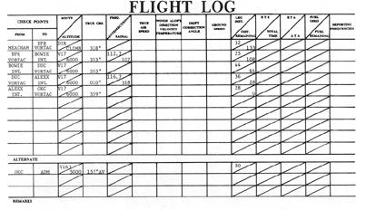
information related to the planning procedure. 1. Airman's Information Manual; AIRCRAFT DATA - FASTFLIGHT N5432K The aircraft is a 5- to 7-place twin-engine "Fast-flight" typical of various light twins in current use. It is appropriately equipped for instrument flight and has the following radio equipment: One L/MF receiver Preflight Action As you proceed with the preflight steps, refer to the flight logs and the sources listed within the parentheses. Step 1, for example, refers you to (a) Federal Aviation Regulations, which specify what checks are REQUIRED and (b) AVIATION WEATHER, AC 00-6A and AVIATION WEATHER SERVICES, AC 00-45B, which explain the meaning of the weather information. STEP 1. PRELIMINARY WEATHER CHECK. Regardless of how good the current weather looks in your departure area, you may save planning time by making use of forecast services well in advance of your expected departure time. Usually, a detailed forecast is accurate for about 6 hours in advance. Beyond 24 hours, only general weather outlooks are possible. It is therefore important to know the types of forecasts available, their filing times, and their valid times. Familiarization with weather service facilities as you plan practice IFR flights in VFR weather conditions is excellent preparation for all-weather flying capability. (FAR 91. AVIATION WEATHER, AC 00-6A, AVIATION WEATHER SERVICES, AC 00-45B, and the weather data at the end of this chapter.) STEP 2. TENTATIVE ROUTE(S) TO DESTINATION AND ALTERNATE(S). If possible, choose preferred routes and select more than one alternate if weather is marginal. Start preparation of flight log (Fig. 13-2). (FAR 91.83(a)(5) {§ 91.83 recodified to § 91.153}; Enroute Chart(s); AIRMAN'S INFORMATION MANUAL; AIRPORT/FACILITY; NOTICES TO AIRMEN (CLASS II); Winds Aloft Forecasts.) a. PROPOSED ALTITUDE. This will depend on factors such as aircraft performance and equipment, winds aloft, freezing level, turbulence, cloud tops, and minimum instrument altitudes. (FAR 91.119 {§ 91.119 recodified to § 91.177}; FAR 91.121(a) {§ 91.121 recodified to § 91.179} and (b).) b. ROUTE AND CHECK POINTS. A study of Enroute Low Altitude Chart L-13 indicates that direct BPR and V17 is an appropriate route from Fort Worth to Oklahoma City since no preferred route is listed. Enroute check points which can be used are Bridgeport VORTAC, Bowie Intersection, Duncan VORTAC, and Alexx Intersection. (FAR 91.123 {§ 91.123 recodified to § 91.181}; Enroute Low Altitude Chart segment inside back cover.) c. TRUE OR MAGNETIC COURSES. The courses entered on the sample flight log are true courses. Some pilots reference their computations to true direction; others to magnetic. If you start with magnetic direction in your computations, winds aloft data must be corrected for variation; if you use winds aloft as reported or forecast (true direction/knots), magnetic courses shown on the chart must be corrected for variation. d. DISTANCES. The first leg (32 NM) entered on the flight log is measured from the departure airport (Meacham) to the first enroute fix, Bridgeport VORTAC. Although you can expect a handoff to Oklahoma City Approach Control for a vector to Wiley Post, the entries shown in Figure 13-2 are adequate for flight planning purposes. Your flight plan will supply ATC with the necessary route data in the event of radio communications failure. e. COMMUNICATIONS/NAVIGATION FREQUENCIES. You may wish to list the VOR frequencies and radials used to establish intersections in the "Reporting Frequencies" column. You may also use this column to note the frequencies as ATC assigns them enroute. It is a good idea to record the ARTCC Sector Discrete Frequencies for each Center involved in your flight. For this flight, you should record 126.0 - Blue Mound, 135.6 - Wichita Falls, and 128.3 - Oklahoma City. (FAR 91.125. {§ 91.125 recodified to § 91.183}) STEP 3. CURRENT INSTRUMENT APPROACH PROCEDURE CHARTS FOR - a. Meacham (for the possibility of an emergency return after takeoff).
Figure 13-2. Flight log entries.
STEP 4. CURRENT INFORMATION ON FACILITIES AND PROCEDURES RELATED TO YOUR FLIGHT, INCLUDING - a. AIRPORT/FACILITY DIRECTORY. Check airport conditions, including
lighting, obstructions, and other notations under "Airport Remarks." Also, check
services at destination and alternate. STEP 5. CONTACT FLIGHT SERVICE STATION IN PERSON OR BY TELEPHONE FOR PREFLIGHT BRIEFING. Refer to page 194 for details concerning the information provided by FSSs during a pilot preflight briefing. (FAR 91.5 {§ 91.5 recodified to § 91.103}; current AIRMAN'S INFORMATION MANUAL; AVIATION WEATHER, AC 00-6A; AVIATION WEATHER SERVICES, AC 00-45B; weather data at the end of this
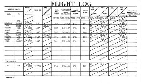
chapter.) a. True airspeed, wind data, groundspeed. On the completed flight log (Fig. 13-3), note that the enroute times are computed to the tenth of a minute. In actual practice, the figures are rounded off. Note also that the groundspeed (166 knots) from Meacham to BPR VORTAC is computed on the basis of the winds aloft at 3,000 feet for DAL (210° at 16 knots) and an assumed average temperature of +8° Celsius. The other true airspeed values are based on 165 knots CAS and on the temperatures given in the winds aloft data for the flight planned altitudes. The only estimated arrival time is logged at BPR VORTAC; the other ETAs are added enroute. The fuel REQUIRED is computed as follows, based on an average
consumption of 40 gph:
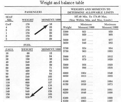
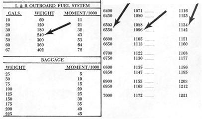
(FAR 91.23 {§ 91.23 recodified to § 91.167}; Aircraft Flight Handbook data in this chapter; weather data for wind forecasts.) STEP 7. COMPUTE WEIGHT AND BALANCE. To the empty weight and oil data given, enter weights for pilot, instructor, and fuel. Assume 196 gallons total fuel load. The moments are derived from the weight and balance chart (at the end of this chapter), and the minimum and maximum moments (shown under "limits" in the following table) are interpolations between 6,500 and 6,550 pounds. (FAR 91.31 {§ 91.31 recodified to § 91.9}; Aircraft Flight Handbook data;
Pilot's Weight and Balance Handbook, AC 91-23A.)
Totals.......................
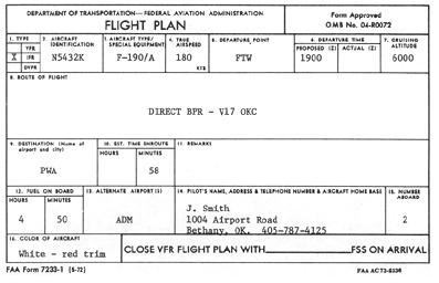
6,531 1,119.8 STEP 8. COMPLETE THE FLIGHT PLAN (FAA Form 7233-1) and file with FSS at least 30 minutes before estimated departure time (Fig. 13-4). Figure 13-3. Completed flight log.
Instrument Weather Flying Your first flight under instrument conditions - like your first solo, first night flight, and first simulated instrument flight under the hood - will probably involve some normal apprehensions. Notwithstanding your temperament, quality of your training, and the thoroughness of your flight planning, the decision to fly under instrument conditions is a commitment for which you ALONE are responsible. What affects your decision to go ahead with an IFR flight or to wait out a weather change for VFR conditions? Your instructor will probably elaborate on the following considerations affecting your judgment. Flying Experience. The more experience, the better - both VFR and IFR. Night flying promotes both instrument proficiency and confidence. Progressing from night flying under clear, moonlit conditions to flying without moonlight, natural horizon, or familiar landmarks, you learn to trust your instruments with a minimum dependence upon what you can see outside the aircraft. The more VFR experience you have in terminal areas with high traffic activity, the more capable you can become in dividing your attention between aircraft control, navigation, communications, and other cockpit duties. The greater your total experience, the greater the number of unexpected situations you have behind you, the fewer surprises you can expect ahead. If you have had the benefit of instrument instruction under instrument weather conditions as well as under the hood, you may have noted that weather flying seemed routine to the instructor. This is the mark of a professional; the unusual is routine because the professional expects it and is ready for it before it happens. Figure 13-4. Flight plan entries.
Recency of experience is an equally important consideration. You may not act as pilot-in-command of an aircraft under IFR or in weather conditions less than VFR minimums unless you have met the requirements of FAR 61.57. Remember, these are minimum requirements. Whether they are adequate preparation for YOU is another question. Airborne Equipment and Ground Facilities. Here again, regulations
specify MINIMUM equipment for filing an IFR flight plan. It is your own
responsibility to decide on the adequacy of your aircraft and NAV/COM equipment
for the conditions expected. A single-engine, well-equipped aircraft in
excellent condition and flown by a competent pilot is obviously safer under
instrument conditions than a twin, superbly equipped and in perfect condition,
in the hands of a reckless or ill-prepared pilot. Whether your aircraft is
single-engine or multiengine, its performance limitations, accessories, and
general condition are directly related to the weather, route, altitude, and
ground facilities pertinent to your flight, as well as to the cockpit workload
you can expect. Weather Data SA 111800 AVIATION WEATHER REPORTS
(SA) DFW FA 111240 NM OK TX AND CSTL WTRS... HGTS ASL UNLESS NOTED... SYNS...LO PRES TROF ALG DHT-MRF LN MOVG EWD 15 KTS TO A END-DRT LN BY 07Z. WRM FNT LRD-PSX-60 S BPT LN MOVG SLOLY NWD TO A BWD-ACT-LFK LN BY 07Z. SIGCLDS AND WX... TX E OF TROF AND S OF WRM FNT AND CSTL WTRS... TX W OF TROF AND NM... ICG...LGT TO MDT MXD ICGICIP ABV FRZG LVL. FRZG LVL 80 NRN NM NRN OK SLPG TO 125 EXTRM S TX. AREA FORECAST (FA)
ADM 111515 C10 OVC 3R-F CHC C3X 1R-F. 18Z C12 OVC 4-F. 01Z
TERMINAL FORECASTS
(FT) FDUS1 KWBC 111740 VALID 120000Z FOR USE 1800-0300Z. TEMPS NEG ABV 24000 FT 3000 6000 9000 12000 18000 24000 DAL 2116 2419+07 2321-01 2223-06 2438-21 2253-33 WINDS AND TEMPERATURES ALOFT FORECAST (FD)
DFW WA 111735 AIRMET BRAVO 4. FLT PRCTN. OVR OK AND TX AND CSTL WTRS AIRMET
(WA) Weight and balance table
|