| Section 5. Altitude Assignment and Verification
4-5-1 Vertical Separation Minima
Separate instrument flight rules (IFR) aircraft using the following
minima between altitudes:
a. Up to and including FL 290 - 1,000 feet.
b. Above FL 290 - 2,000 feet, except
1. In oceanic
airspace, above FL 450 between a supersonic and any other aircraft - 4,000 feet.
2. Above FL 600 between military aircraft - 5,000 feet.
{New-98-8 Revised August 13, 1998}
3. Apply 1,000 feet between approved aircraft if:
(a) Operating within airspace and altitude(s) designated
for reduced vertical separation minimum (RVSM) or,
(b)
Operating within RVSM transition airspace and designated altitude(s) if en route
to/from RVSM designated airspace.
{New-98-8 Revised August 13, 1998}
NOTE -
1 - Oceanic separation procedures are supplemented in
Chapter 8, Section 7, Section 8, Section 9, and Section
10.
2 - RVSM and RVSM transition airspace is designated in ICAO Regional
Supplementary Document, Doc.
7030.4, and via International
NOTAM.
REFERENCE -
FAAO 7110.65, Vertical Application, paragraph 5-5-4.
FAAO
7110.65, Application, paragraph 6-6-1.
FAAO 7110.65, Military Operations
Above FL 600, paragraph 9-3-11.
4-5-2 Flight Direction
Clear aircraft at altitudes according to the Table 4-5-1.
Table 4-5-1 - Altitude Assignment
----------------------------------------------------------------
AIRCRAFT OPERATING: Below 3,000 feet above surface
ON COURSE DEGREES MAGNETIC: Any course
ASSIGN:
Any altitude
----------------------------------------------------------------
AIRCRAFT OPERATING: Below FL 290
ON COURSE DEGREES MAGNETIC: 0 through 179
ASSIGN: Odd cardinal altitudes or flight levels at
intervals of
2,000 feet.
EXAMPLES: 3,000, 5,000, FL 250, FL 270
ON COURSE DEGREES MAGNETIC: 180 through 359
ASSIGN: Even cardinal altitude or flight levels at
intervals of
2,000 feet.
EXAMPLES: 4,000, 6,000, FL 240, FL 260
-----------------------------------------------------------------
AIRCRAFT OPERATING: At or above FL 290
ON COURSE DEGREES MAGNETIC: 0 through 179
ASSIGN: Odd cardinal flight levels at intervals
of 4,000 feet
beginning with FL 290
EXAMPLES: FL 290, FL 330, FL 370
ON COURSE DEGREES MAGNETIC: 180 through 359
ASSIGN: Odd cardinal flight levels at intervals
of 4,000 feet
beginning with FL 310
EXAMPLES: FL 310, FL 350, FL 390
-----------------------------------------------------------------
AIRCRAFT OPERATING: One way routes (except in composite
systems)
ON COURSE DEGREES MAGNETIC: Any course
ASSIGN: Any cardinal altitude or flight level
below FL 290 or
any odd cardinal flight level
at or above FL
290
EXAMPLES: FL 270, FL 280, FL 310, FL 330
-----------------------------------------------------------------
AIRCRAFT OPERATING: Within an ALTRV
ON COURSE
DEGREES MAGNETIC: Any course
ASSIGN: Any altitude or flight
level
-----------------------------------------------------------------
AIRCRAFT OPERATING: In transition to/from or within Oceanic
airspace where composite separation is authorized
ON COURSE
DEGREES MAGNETIC: Any course
ASSIGN: Any odd or even cardinal
flight level
including those above FL 290
EXAMPLES: FL 280, FL 290, FL 300,
FL 310, FL 320, FL 330, FL 340
-----------------------------------------------------------------
AIRCRAFT OPERATING: In aerial refueling tracks and anchors
ON COURSE DEGREES MAGNETIC: Any course
ASSIGN:
Altitude blocks as requested. Any altitude or flight level
EXAMPLES: 050B080, FL180B220, FL280B310
------------------------------------------------------------------------------------------
{New-98-8 Revised August 13, 1998}
AIRCRAFT OPERATING: Approved Aircraft within RVSM or RVSM
transition airspace
ON COURSE DEGREES MAGNETIC: Any course
ASSIGN: Any designated cardinal altitude
EXAMPLES: FL330, FL340, FL350, FL360
---------------------------------------------------------------------
NOTE -
Oceanic separation procedures are supplemented in Chapter 8,
Section 7, Section 8, Section 9, and Section 10.
REFERENCE -
FAAO 7110.65, Exceptions, paragraph 4-5-3.
FAAO 7110.65,
Altitude Assignments, paragraph 7-7-5.
FAAO 7110.65, Separation Minima,
paragraph 9-4-2.
4-5-3 Exceptions
When traffic, meteorological conditions, or aircraft operational
limitations prevent assignment of altitudes prescribed in paragraph 4-5-2,
Flight Direction, assign any cardinal altitude or flight level below FL 290 or
any odd cardinal flight level at or above FL 290 without regard to direction of
flight as follows:
NOTE -
See paragraph 2-3-9, Control Symbology, for control abbreviations
and symbols to be used in conjunction with this paragraph.
a. For
traffic conditions, take this action only if one of the following conditions
exists:
1. Aircraft remain within a facility's area and prior
approval is obtained from other affected positions or sectors or the operations
are covered in a Facility Directive.
2. Aircraft will proceed beyond
the facility's area and specific operations and procedures permitting random
altitude assignment are covered in a letter of agreement between the appropriate
facilities.
NOTE -
Those en route facilities using HOST software that provides
capability for passing interim altitude shall include the specific operations
and procedures for use of this procedure in a letter of agreement between the
appropriate facilities.
b. Military aircraft are operating on random
routes and prior approval is obtained from the facility concerned.
c.
For meteorological conditions, take this action only if you obtain prior
approval from other affected positions or sectors within your facility and, if
necessary, from the adjacent facility concerned.
d. For aircraft
operational limitations, take this action only if the pilot informs you the
available appropriate altitude exceeds the operational limitations of his
aircraft and only after you obtain prior approval from other affected positions
or sectors within your facility and, if necessary, from the adjacent facility
concerned.
e. For mission requirements, take this action only when the
aircraft is operating on an MTR.
REFERENCE -
FAAO 7110.65, Altitude Assignments, paragraph 7-7-5.
FAAO
7110.65, Separation Minima, paragraph 9-4-2.
4-5-4 Lowest Usable Flight Level
If a change in atmospheric pressure affects a usable flight level in
your area of jurisdiction, use Table 4-5-2 to determine the lowest usable flight
level to clear aircraft at or above 18,000 feet MSL.
Table 4-5-2
Lowest Usable FL
--------------------------------------
Altimeter
Setting Lowest Usable FL
--------------------------------------
29.92" or
higher
180
29.91" to
28.92"
190
28.91" to
27.92"
200
--------------------------------------
REFERENCE -
FAAO 7110.65, Separation Minima, paragraph 9-4-2.
4-5-5 Adjusted Minimum Flight Level
When the prescribed minimum altitude for IFR operations is at or above
18,000 feet MSL and the atmospheric pressure is less than 29.92", add the
appropriate adjustment factor from Table 4-5-3 to the flight level equivalent of
the minimum altitude in feet to determine the adjusted minimum flight level.
Table 4-5-3
Minimum FL Adjustment
---------------------------------------
Altimeter
Setting Adjustment Factor
---------------------------------------
29.92" or
higher None
29.91" to
29.42" 500 feet
29.41" to
28.92" 1,000 feet
28.91" to
28.42" 1,500 feet
28.41" to
27.92" 2,000 feet
---------------------------------------
4-5-6 Minimum En route Altitudes
Except as provided in subparagraphs a and b below, assign altitudes at
or above the MEA for the route segment being flown. When a lower MEA for
subsequent segments of the route is applicable, issue the lower MEA only after
the aircraft is over or past the Fix/NAVAID beyond which the lower MEA applies
unless a crossing restriction at or above the higher MEA is issued.
a.
An aircraft may be cleared below the MEA but not below the MOCA for the route
segment being flown if the altitude assigned is at least 300 feet above the
floor of controlled airspace and one of the following conditions are met:
NOTE -
Controllers must be aware that in the event of radio
communications failure, a pilot will climb to the MEA for the route segment
being flown.
1. Nonradar procedures are used only within 22 miles of
a VOR, VORTAC, or TACAN.
2. Radar procedures are used only when an
operational advantage is realized and the following actions are taken:
(a) Radar navigational guidance is provided until the aircraft
is within 22 miles of the NAVAID, and
(b) Lost communications
instructions are issued.
b. An aircraft may be cleared to operate on
jet routes below the MEA (but not below the prescribed minimum altitude for IFR
operations) or above the maximum authorized altitude if, in either case, radar
service is provided.
NOTE -
Minimum en route and maximum authorized altitudes for certain jet
route segments have been established above the floor of the jet route structure
due to limitations on navigational signal coverage.
c. Where a higher
altitude is required because of an MEA, the aircraft shall be cleared to begin
climb to the higher MEA as follows:
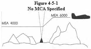
1. If no MCA is specified, prior to or immediately after passing the
fix where the higher MEA is designated. (See Figure 4-5-1)
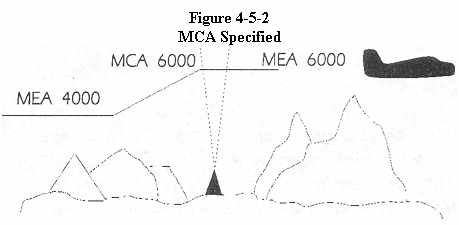
2. If a MCA is specified, prior to the fix
so as to cross the fix at or above the MCA. (See Figure 4-5-2)
d. Where MEAs have not been established, clear an aircraft at or above
the minimum altitude for IFR operations prescribed by FAR Part 91.177.
REFERENCE -
FAAO 7110.65, IFR-VFR and VFR-IFR Flights, paragraph 4-2-8.
FAAO 7110.65, Route Use, paragraph 4-4-1.
FAAO 7110.65, Application,
paragraph 5-6-1.
FAAO 7110.65, Altitude Assignments, paragraph 7-7-5.
4-5-7 Altitude Information
Issue altitude instructions as follows:
REFERENCE -
FAAO 7110.65, Clearance Items, paragraph 4-2-1.
a.
Altitude to maintain or cruise. When issuing cruise in conjunction with an
airport clearance limit and an unpublished route will be used, issue an
appropriate crossing altitude to ensure terrain clearance until the aircraft
reaches a fix, point, or route where the altitude information is available to
the pilot. When issuing a cruise clearance to an airport which does not have a
published instrument approach, a cruise clearance without a crossing restriction
may be issued.
PHRASEOLOGY -
MAINTAIN/CRUISE (altitude). MAINTAIN (altitude) UNTIL
(time),
or
PAST (fix),
or
(number of
miles or minutes) MILES/MINUTES PAST (fix).
CROSS (fix, point)
or
INTERCEPT (route) AT OR ABOVE (altitude), CRUISE
(altitude).
NOTE -
1 - The crossing altitude must assure IFR obstruction
clearance to the point where the aircraft is established on a segment of a
published route or instrument approach procedure.
2 - When an aircraft is
issued a cruise clearance to an airport which does not have a published
instrument approach procedure, it is not possible to satisfy the requirement for
a crossing altitude that will ensure terrain clearance until the aircraft
reaches a fix, point, or route where altitude information is available to the
pilot. Under those conditions, a cruise clearance without a crossing restriction
authorizes a pilot to determine the minimum IFR altitude as prescribed in FAR
Part 91.117 and descend to it at pilot discretion if it is lower than the
altitude specified in the cruise clearance.
b. Instructions to climb
or descend including restrictions, as required. Specify a time restriction
reference the UTC clock reading with a time check. If you are relaying through
an authorized communications provider, such as ARINC, FSS, etc., advise the
radio operator to issue the current time to the aircraft when the clearance is
relayed.
EXAMPLE -
[1] "United Four Seventeen, climb to reach one three thousand
at two two one five.
Time two two one one and one-quarter."
The pilot is expected to be level at 13,000 feet at 2215 UTC.
[2]
Through Relay - "Speedbird Five, climb to reach flight level three-five zero at
one-two-one-five, time" (Issue a time check).
REFERENCE -
FAAO 7110.65, Word Meaning, paragraph 1-2-1.
FAAO
7110.65, Numbers Usage, paragraph 2-4-17.
PHRASEOLOGY -
CLIMB/DESCEND AND MAINTAIN (altitude).
If required,
AFTER PASSING (fix),
or
AT (time) (Time in hours, minutes, and
nearest quarter minute.)
CLIMB/DESCEND TO REACH (altitude)
AT (time
(issue time check) or fix)
or
AT (time). CLIMB/DESCEND AND MAINTAIN
(altitude)
WHEN ESTABLISHED AT LEAST (number of miles or minutes)
MILES/MINUTES PAST (fix) ON THE (NAVAID) (specified) RADIAL.
CLIMB/DESCEND
TO REACH (altitude) AT (time or fix).
or
A POINT (number of miles) MILES
(direction) OF (name of DME NAVAID).
Through Relay:
CLIMB TO REACH
(altitude) AT (time) (issue a time check).
c. Specified altitude over
a specified fix.
PHRASEOLOGY -
CROSS (fix) AT (altitude).
CROSS
(fix) AT OR ABOVE/BELOW (altitude).
d. A specified altitude over a
specified fix for that portion of a descent clearance where descent at pilot's
discretion is permissible. At any other time it is practicable, authorize
climb/descent at pilot's discretion.
PHRASEOLOGY -
CLIMB/DESCEND AT
PILOT'S DISCRETION.
EXAMPLE -
"United Four Seventeen, descend and
maintain six thousand."
NOTE -
The pilot is expected to commence descent upon receipt of
the clearance and to descend at the suggested rates specified in the AIM,
Adherence to Clearance, paragraph 4-4-9 until reaching the assigned altitude of
6,000 feet.
EXAMPLE -
"United Four Seventeen, descend at pilot's discretion, maintain
six thousand."
NOTE -
The pilot is authorized to conduct descent within the context of
the term "at pilot's discretion" as described in the AIM.
EXAMPLE -
"United Four Seventeen cross Lakeview VOR at or above flight
level two zero zero, descend and maintain six thousand."
NOTE -
The pilot is authorized to conduct descent "at pilot's discretion"
until reaching Lakeview VOR. The pilot must comply with the clearance provision
to cross the Lakeview VOR at or above FL 200, and after passing Lakeview VOR,
the pilot is expected to descend at the rates specified in the AIM until
reaching the assigned altitude of 6,000 feet.
EXAMPLE -
"United Four Seventeen, cross Lakeview VOR at and maintain six
thousand."
NOTE -
The pilot is authorized to conduct descent "at pilot's
discretion," but must comply with the clearance provision to cross Lakeview VOR
at 6,000 feet.
EXAMPLE -
"United Four Seventeen, descend now to flight level two seven
zero, cross Lakeview VOR at or below one zero thousand, descend and maintain six
thousand."
NOTE -
The pilot is expected to promptly execute and complete descent to
FL 270 upon receipt of the clearance. After reaching FL 270, the pilot is
authorized to descend "at pilot's discretion" until reaching Lakeview VOR. The
pilot must comply with the clearance provision to cross Lakeview VOR at or below
10,000 feet. After Lakeview VOR, the pilot is expected to descend at the rates
specified in the AIM until reaching 6,000 feet.
NOTE -
1 - A descent clearance which specifies a crossing altitude
authorizes descent at pilot's discretion for that portion of the flight to which
the crossing altitude restriction applies.
2 - Any other time that
authorization to descend at pilot's discretion is intended, it must be
specifically stated by the controller.
3 - The pilot may need to know of any
future restrictions that might affect the descent, including those that may be
issued in another sector, in order to properly plan a descent at pilot's
discretion.
4 - Controllers need to be aware that the descent rates in the
AIM are only suggested and aircraft will not always descend at those rates.
REFERENCE -
P/CG term - Pilot's Discretion.
e. When a portion
of a climb/descent may be authorized at the pilot's discretion, specify the
altitude the aircraft must climb/descend to followed by the altitude to maintain
at the pilot's discretion.
PHRASEOLOGY -
CLIMB/DESCEND NOW TO (altitude), THEN CLIMB/DESCEND AT
PILOT'S DISCRETION MAINTAIN (altitude).
EXAMPLE -
"United three ten, descend now to flight level two eight zero,
then descend at the pilot's discretion maintain flight level two four zero."
NOTE -
1 - The pilot is expected to commence descent upon receipt of the
clearance and to descend at the suggested rates specified in the AIM Section on
ATC Clearances/Separations, Adherence to Clearances, paragraph 4-4-9, until
reaching flight level 280. At that point, the pilot is authorized to continue
descent to flight level 240 within the context of the term "at pilot's
discretion" as described in the AIM.
2- Controllers need to be aware that
the descent rates in the AIM are only suggested and aircraft will not always
descend at those rates.
f. When the "pilot's discretion" portion of a
climb/descent clearance is being canceled by assigning a new altitude, inform
the pilot that the new altitude is an "amended altitude."
EXAMPLE -
"American Eighty Three, amend altitude, descend and maintain
flight level two six zero."
NOTE -
American Eighty Three, at flight level 280, has been cleared to
descend at pilot's discretion to flight level 240. Subsequently, the altitude
assignment is changed to flight level 260, therefore, pilot's discretion is no
longer authorized.
g. Altitude assignments involving more than one
altitude.
PHRASEOLOGY -
MAINTAIN BLOCK (altitude) THROUGH (altitude).
h.
Instructions to vertically navigate on a STAR/FMSP with published restrictions.
PHRASEOLOGY -
DESCEND VIA (STAR, FMSP name and number).
EXAMPLE -
"Descend via the Mudde One Arrival"
"Cross JCT at flight
level two four zero."
"Descend via the Coast Two Arrival."
NOTE -
Clearance to "descend via" authorizes a pilot's discretion descent
to comply with published altitude and/or speed crossing restrictions. "Expect"
altitudes/speeds are not considered STAR/FMSP crossing restrictions until
verbally issued by ATC. Their used by pilots is for planning purposes or lost
communications procedures.
1. If it is necessary to assign a crossing
altitude which differs from the STAR/FMSP altitude, emphasize the change to the
pilot.
PHRASEOLOGY -
DESCEND VIA THE (STAR/FMSPO ARRIVAL EXCEPT (revised
altitude information).
REFERENCE -
FAAO 7110.65, Clearance Information, paragraph 4-7-1 AIM,
STARS/FMSPS, paragraph 5-4-1.
i. When a pilot is unable to accept a
clearance, issue revised instructions to ensure positive control and standard
separation.
NOTE -
1 - CFR Part 91.123 states that a pilot is not allowed to deviate
from an ATC clearance "that has been obtained...unless an amended clearance is
obtained" (except when an emergency exists).
2 - A pilot is therefore
expected to advise the controller if a clearance cannot be accepted when the
clearance is issued. "We will try" and other such acknowledgements do not
constitute pilot acceptance of an ATC clearance.
3 - Controllers are
expected to issue ATC clearances which conform with normal operational
capabilities for each aircraft and do not require "last minute" amendments to
ensure standard separation.
4 - "Expedite" is not to be used in lieu of
appropriate restrictions to ensure separation.
{New-98-3 Revised February 26, 1998}
REFERENCE -
FAAO 7110.65, Providing Assistance, paragraph
10-1-3.
4-5-8 Anticipated Altitude Changes
If practicable, inform an aircraft when to expect climb or descent
clearance or to request altitude change from another facility.
PHRASEOLOGY -
EXPECT HIGHER/LOWER ALTITUDE IN (number of miles or
minutes) MILES/MINUTES,
or
AT (fix). REQUEST ALTITUDE
CHANGE FROM (name of facility).
If required,
AT (time, fix,
or altitude).
REFERENCE -
FAAO 7110.65, IFR Flight Progress Data, paragraph 2-2-6.
4-5-9 Altitude Confirmation - Nonradar
a. Request a pilot to confirm assigned altitude on initial contact and
when position reports are received unless:
NOTE -
For the purpose of this paragraph, "initial contact" means a
pilot's first radio contact with each sector/position.
1. The pilot
states the assigned altitude, or
2. You assign a new altitude to a
climbing or descending aircraft, or
3. TERMINAL:
The
aircraft was transferred to you from another sector/position within your
facility (intrafacility).
PHRASEOLOGY -
(In level flight situations),
VERIFY AT
(altitude).
In climbing/descending situations,
VERIFY
ASSIGNED ALTITUDE (altitude).
b. USA: Reconfirm all pilot altitude
readbacks.
PHRASEOLOGY -
If altitude readback is correct,
AFFIRMATIVE (altitude).
If altitude readback is not correct,
NEGATIVE. CLIMB/DESCEND AND MAINTAIN (Altitude),
or
NEGATIVE. MAINTAIN (altitude).
 |
FAATest.com
- Aviation Library
Dauntless
Software hosts and maintains this library as a service to pilots
and aspiring pilots worldwide. Click
here for ways to show your appreciation for this service.
While much of this material comes from the FAA, parts of it are (c) Dauntless Software, all rights reserved. Webmasters: please
do not link directly to individual books in this library--rather,
please link to our main web page at www.dauntless-soft.com or
www.faatest.com. Thanks! |
|